
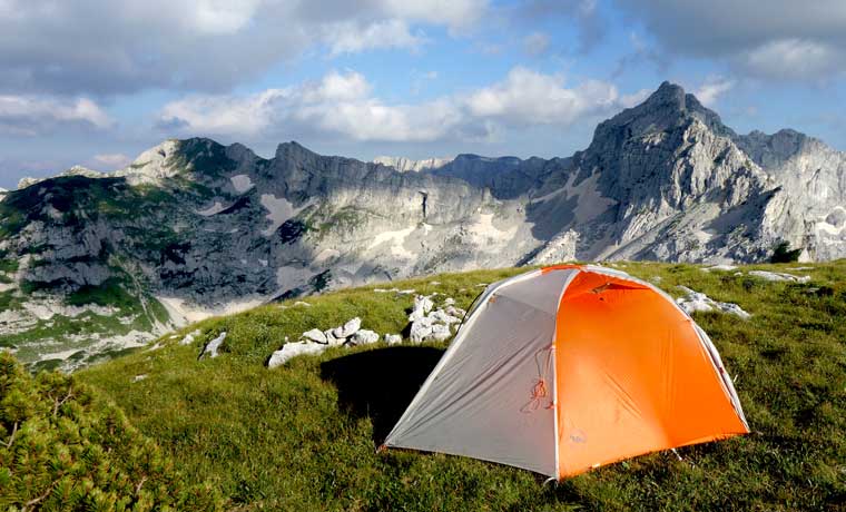
In the northern corner of Montenegro is Durmitor National Park. Part of the Dinaric Alps and covering 390km2, this UNESCO world heritage site is the largest protected area in Montenegro. And for good reason. It’s amazing, remote, rugged, and untouched. In winter it attracts visitors to its ski slopes, which are accessed from Zabljak, the regional capital. But during the summer months an extensive network of mountain trails replaces the basins and snow-filled passes.
Durmitor National Park offers excellent hiking and backpacking opportunities for everyone to enjoy. From short day hikes around crystal clear lakes, to popular multi-day treks covering high peaks and deep valleys.
We spent 5 days in the area in mid-June. And with a window of unusually good weather opening, we hit the trails for a three-night hike in the mountains.
Hiking in Durmitor National Park
Day 1: Black Lake to Katun Lokvice
We didn’t leave the park entrance until around 7.30pm. On the other hand, this meant that we had the trail entirely to ourselves. But it also meant that the last 30 minutes of the route was done almost in the dark. The fireflies obliged, however, (as did the well-marked trail), and kept us on track, reaching Katun Lokvice after just 2 hours of hiking. We camped next to other tents and slept on the ground.
There is a natural spring in a basin just west of the camp where you can refill your water.
Day 2: Katun Lokvice to Zeleni Vir via Bobotov Kuk
Our first ‘proper’ hiking day involves the summit of Bobotov Kuk – the highest peak in Durmitor National Park. At 2,523 m (8,278 ft) it is thought to be the highest point in Montenegro. Our fellow campers set off from the parks to tackle Bobotov Kuk before returning to Katun Lokvice for one day. Many climbers attempt the summit from Black Lake or Sedlo (and back) in a day. However, we wanted to go deeper into the mountains. So we packed up everything and started climbing slowly past and around alpine basins, meadows and boulders towards the summit.
Despite being the middle of July, there were still small sections of the road covered in snow and ice. But this was a breeze compared to the steep scree section up to the deck before the final push to the summit. Extra care should be taken at this stage as many large boulders can be easily dislodged – a death trap for climbers who fall down the slope.

We decided to drop our packs on the horse and enjoyed an easy hike up to the top, where we were treated to a spectacular view of the surrounding mountains. Our slow start meant we enjoyed the summit on our own, meeting other hikers on the way down.
Another hour of climbing took us to Zeleni Vir, a VERY COLD lake that allowed us to clean and rehydrate.
Day 3: Zeleni Vir to Planinica
Another day of blue skies, a cool breeze and amazing views kept spirits high, despite a small food packing error. Yes, I failed to feed two of us one meal. Summit Surprise Rice pudding to the rescue!
But the beautiful and varied route, the long stop at Veliko Skrcko Jezero (lake), and the joy of reaching the top of Planinica after a steady 2-hour climbing slog, certainly took my mind off any calories I was missing!
It’s great to camp anywhere you like in Durmitor National Park. That said, the rangers seemed to encourage us to go to the designated camping areas where you can camp for a small fee, or choose to stay in the mountain huts. But we chose to stay off the beaten path (as much as possible), and it really paid off.

The summit of Planinica offered even more spectacular views than Bobotov Kuk. And to our relief, it also provided a perfect camping spot. Normally, this highly exposed peak would not be very attractive to prospective campers. But the clear sky, the breeze and the high clouds in the distance promised the calm night that many people dreamed of. It really was something you only see in the newspapers, taken after three days of sitting in a tent waiting for the storms to pass. However, we entered Durmitor and found exactly what we were looking for. So thank you very much.
Day 4: Planinica to Black Lake
Our last day was the most downhill. Some sections are steep, some winding, but each is as good as the last. The meadows in the mountains became more colorful and green the lower we found them, until we reached the last part of the forest where tall pine trees replaced the flower show.
The two small lakes on the upper part of the trail were almost dry. The water that was there was polluted by cattle. We decided we had enough water to not risk it, and split our water for the day. As it turned out, we managed to filter the water after only a few hours in Crepulj Poljana.

Although we met many hikers at Bobotov Kuk, we only encountered a few multi-day backpackers. And most of our time hiking in Durmitor National Park, it felt like we had the place to ourselves.
But it wasn’t just the seemingly untouched silence that captured our hearts. The place I had never been was nowhere else. It’s amazing, it’s amazing, it’s diverse and it’s always changing. At one point the soft, green valley is cut by huge ancient rolling stones. Next, tall limestone pillars fall over deep basins filled with pebbles. Then before your senses have a chance to process it all, you’ll walk right into rainbow-filled meadows, alive with the dance of insects and the breeze. A must for tourists, even if hiking isn’t really your thing.

Top tips for hiking in Durmitor National Park
-
The weather
As with all mountains, the weather is very variable. Daytime temperatures during our July trip soared into the mid/high 20’s (ºC), while cool nights dipped below 10ºC (and that was with little wind or rain). Storms come quickly in the mountains, so waterproof jackets and pants are a must.
-
Camping stove and fuel
High gas screws do not really exist in Montenegro. One supermarket, Voli Supermarket in Zabljak, was sold out while we were there! We had a multi-fuel stove, but also struggled to find any fuel suitable for this, other than gasoline. However, you will find many stoves with holes, and cheap stoves that go with them.
-
Water resources
There are very few natural sources of water in the mountains. A few streams and lakes, but you need to be smart about route planning to ensure you have plenty to drink and cook with. The guards will help with this. On the last day we found a few pools, during the less dry times of the year, that would have been nice to swim in.
-
Food options
The local supermarket is well stocked with everything you might need for your camping meals. You won’t find the best frozen meals, but there are plenty of pasta, oats, nuts, dried meat and muesli bars.
-
Mapping
You can find a Durmitor National Park trail map at the tourist information in Zabljak, or at the park entrance. However, if you are familiar with Ordnance Survey maps then using the mapping system is worth doing. We use ViewRanger Maps that download and track your location via GPS. You can also find local clues on zabljak.com.
-
Access to the national park
You have to pay to enter the park, although no one checked our ticket. You can fix this at the park entrance.
Hiking in Durmitor National Park was the highlight of my year. They are more difficult to get to than the Alps, but once you find the place (almost) yourself, it’s worth the effort.
For those looking to hike in the UK, check out these routes in Snowdonia National Park.